Der globale Meeresspiegel steigt und steigt – und das seit 15.000 Jahren. Allerdings gibt es Hinweise darauf, dass der Anstieg nicht kontinuierlich war und es Phasen gab, wo der Meeresspiegel stabil blieb, vielleicht sogar gefallen ist. Dies könnte z.B. in den natürlichen Kältephasen passiert sein, die es etwa alle 1000 Jahre gab.
Anhand von geologischen Methoden ist es möglich, die Meeresspiegelgeschichte zu rekonstruieren. Eine Forschergruppe um Sarah Woodroffe von der Universität Durham in Nordengland hat die Entwicklung des Meeresspiegels in Tansania und auf den weit vor der ostafrikanischen Küste vorgelagerten Seychellen näher unter die Lupe genommen. In einer ersten Studie, die im Mai 2015 im Fachblatt The Holocene erschien, rekonstruieren Woodroffe und Kollegen die Schwankungen an der Küste Tansanias der letzten 10.000 Jahre. Zunächst stieg der Meeresspiegel schnell an und erreichte vor 7900 Jahren ein Niveau um drei Meter fünfzig unterhalb des heutigen Niveaus. Neunhundert Jahre später erreichte das Meer dann den heutigen Stand. Der Anstieg verlangsamte sich daraufhin. Es kann nicht ausgeschlossen werden, dass der Meeresspiegel in der Folgezeit über dem heutigen Niveau lag. In den letzten 4400 Jahren fiel der Meeresspiegel dann wieder bzw. blieb konstant.
Im Folgenden die Kurzfassung der Arbeit:
Radiocarbon dating of mangrove sediments to constrain Holocene relative sea-level change on Zanzibar in the southwest Indian Ocean
Mangrove sedimentary deposits are sensitive to changes in sea level and can be used to reconstruct mid- to late Holocene sea-level fluctuations in intermediate and far-field locations, distant to the former polar ice sheets. However, they can be difficult to date using 14C because mangrove sediment can contain mixtures of carbon of different ages. The two main potential causes of error are younger mangrove roots penetrating down through the sediment column and bioturbation by burrowing animals which moves carbon up and down the sediment column. Both processes may introduce carbon not representative of the age of deposition of the layer being dated. This study reports new 14C dates on organic concentrates (10–63 µm) from mangrove sediments from Makoba Bay on Zanzibar (Unguja) where previous bulk sediment 14C age–depth profiles contained inversions and were therefore less useful for relative sea-level (RSL) reconstruction. Dates on organic concentrates provide a more coherent sequence of 14C ages compared with those from bulk sediments. These new data provide an improved environmental history and mid- to late Holocene RSL record for this site. Our reconstructions show that RSL rose during the mid-Holocene and reached within −3.5 m of present by c. 7900 cal. yr BP. RSL slowed as it reached present at or shortly after c. 7000 cal. yr BP, with falling and/or stable RSL from c. 4400 cal. yr BP to present. We are not able to determine whether there was a RSL highstand above present on Zanzibar during the mid- to late Holocene. The RSL reconstruction agrees broadly with changes predicted by the ICE-5G geophysical model, which includes 4 m of ice equivalent sea-level rise between 7000 and 4000 cal. yr BP. Our new dating approach has the potential to provide improved chronologies with which to interpret sea level data from this and other mangrove environments.
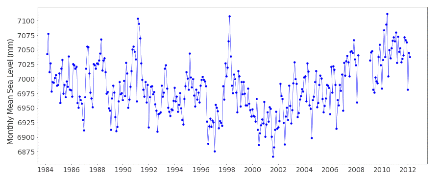
Was für eine Überraschung: In den letzten viereinhalb Jahrtausenden ist der Meeresspiegel in Tansania gefallen bzw. stabil geblieben. Was sagen die aktuellen Küstenpegelmessungen des Landes? Zum Glück gibt es auf Sansibar einen Pegel, der seit 1984 Daten liefert (Abbildung 1). Ein Langzeittrend ist für die letzten 30 Jahre nicht auszumachen. Vielmehr kann eine Art Zyklus vermutet werden, mit einem Abfallen bis 2000 und einem nachfolgenden Wiederanstieg. Das heutige Meeresspiegelniveau wurde in den letzten 30 Jahren mehrfach kurzfristig erreicht.

Abbildung 1 : Meeresspiegelentwicklung am Küstenpegel Sanibar in Tansania. Quelle : PSMSL.
In einer Vergleichsstudie hat das Team um Sarah Woodroffe auch die Seychellen untersucht, die in weiterer Entfernung der tansanianischen Küste vorgelagert sind. Bei dieser abseitigen Lage inmitten des Ozeans können tektonische Hebungs- oder Senkungseffekte praktisch ausgeschlossen werden. Auch hier fanden die Forscher einen sehr stabilen Meeresspiegel in den letzten 2000 Jahren. Im Rahmen der Rekonstruktionsgenauigkeit konnte festgestellt werden, dass der Meeresspiegel in dieser Zeit niemals tiefer als 2m unter dem heutigen Niveau lag. Aber auch Meeresspiegelstände von einigen Dezimetern über dem heutigen Stand können nicht ausgeschlossen werden.
Diese Arbeit erschien in den Quaternary Science Reviews, ebenfalls im Mai 2015: Im Folgenden die Kurzfassung:
New constraints on late Holocene eustatic sea-level changes from Mahé, Seychelles
This study provides new estimates of globally integrated ice sheet melt during the late Holocene (since 4 ka BP) from Seychelles in the western Indian Ocean, a tectonically stable, far field location where the necessary Glacial-Isostatic Adjustment (GIA) correction is small and is relatively insensitive to predictions using different Earth viscosity profiles. We compare sea level data from Seychelles to estimates of eustasy from two GIA models, ICE-5G and EUST3, which represent end-members in the quantity of global melt during the late Holocene. We use data from a range of coastal environments including fringing reef, present day beaches, fossil plateau and mangrove deposits on the largest island of the Seychelles archipelago, Mahé to reconstruct relative sea-level changes. Our data suggest that extensive coastal deposits of carbonate-rich sands that fringe the west coast formed in the last 2 ka and the horizontal nature of their surface topography suggests RSL stability during this period. Mangrove sediments preserved behind these deposits and in river mouths date to c. 2 ka and indicate that RSL was between −2 m and present during this interval. Correcting the reconstructed sea level data using a suite of optimal GIA models based on the two ice models mentioned above and a large number (c. 350) of Earth viscosity models gives a result that is consistent with the sedimentological constraints. When uncertainties in both model results and data are considered, it is possible to rule out eustatic sea levels below c. 2 m and more than a few decimetres above present during the past two millennia. This uncertainty is dominated by error in the reconstructions rather than the model predictions. We note, however, that our estimates of eustasy are more compatible with the EUST3 model compared to the ICE-5G model during the late Holocene (2–1 ka BP). Our evidence from Seychelles shows that the timing of when eustatic sea level first rose close to present is between the predictions of the two end-member GIA models presented here (4 ka BP for ICE-5G and 1 ka BP for EUST3). Using all lines of evidence currently available from Mahé we suggest that the eustatic contribution during the last 2 ka has been less than 2 m. This conclusion is drawn from a tectonically stable, far-field region that is relatively insensitive to earth and ice model uncertainties, and implies that global eustasy has been relatively insensitive to climate fluctuations over the pre-industrial part of the last 2 ka.
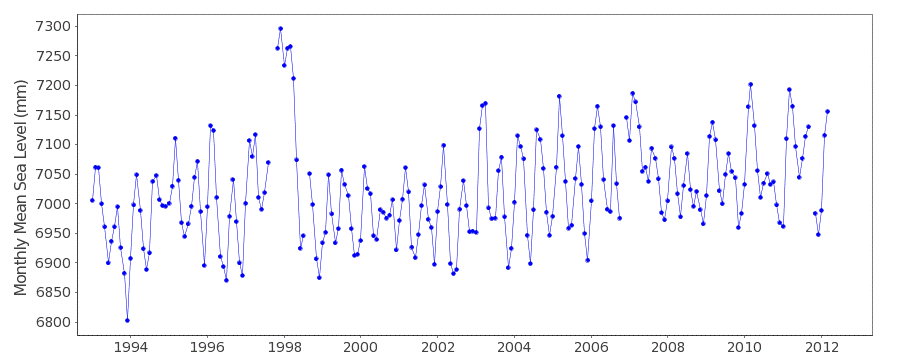
Wieder studieren wir die Küstenpegelmessungen dazu. Die seit 2012 offenbar inaktive Point La Rue-Station zeigt einen interessanten Verlauf: Seit 2002 ist der Meeresspiegel überhaupt nicht mehr angestiegen (Abbildung 2).

Abbildung 2 : Meeresspiegelentwicklung am Küstenpegel Pointe La Rue auf den Seychellen. Quelle : PSMSL.
Was sagen die Satellitenmessungen? Auch hier in den letzten 10 Jahren keinerlei Meeresspiegelanstieg! (Abbildung 3).

Abbildung 3: Meeresspiegelentwicklung im Gebiet der Seychellen auf Basis von Satellitenmessungen. Quelle: University of Colorado.


